
40.7
Foray into Redwood Park
Chapter 1
A Foray into Redwood Park.
As a boy, I enjoyed exploring the countryside in and around Blakehurst. My Father encouraged me by walking with me and describing flora and fauna. In the Sydney where my Father grew up, he walked for three miles through bushland to reach school; this area is now a Sydney suburb. Behind my home, there was undeveloped land, some covered with lantana and the rest with what we called tea tree or montane heath. At the end of the road and across the Princes Highway is a short walk to the Carss Bush Park, which is an extensive expanse of almost natural trees and scrubs. At the waterside area is the original homestead and cemetery of the Carss Family, which overlooks a swimming area with a maritime fence separating it from Kogarah Bay. This Park is the Australian pre-embarkation scene for the film, “Forty Thousand Horsemen”, which is about the light horsemen who were sent to Palestine to be involved in the Beersheba charge. The directors filmed the desert scenes in the Kurnell dunes, another favourite area once I had a car. More recently it was used as a locality for “Packed to the Rafters’. Since my youth, the nearby scrub is under houses, and the Bush Park is manicured grass between the trees. (Georges River Council, 2018).
I joined the Citizen’s Military Force because of my love of trekking where I was paid to walk through the bush. My continuing interest is still with me in Toowoomba, and the idea of exploring the Redwood Park has been on my bucket list for some time.
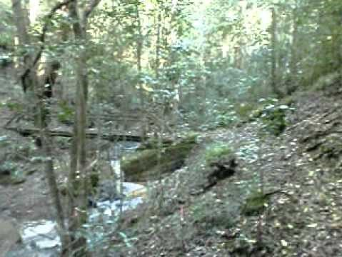
The Redwood Park is on the eastern escarpment of Toowoomba and forms part of the Great Dividing Range which runs down most of the East Coast of Australia. Arriving at the end of Bridge Street as it becomes Prince Henry Heights Drive, there is a parking area at the gates of a quarry. Walkers and off-road bike riders park their cars here. Crossing the road, the walker will arrive at a sign which designates some of the trails for pushbikes and horse riders while reserving the majority of the pathways for hikers. The name of the first is Redwood Forrest Walk; the path leads east for a hundred metres, past solid timber retaining walls before passing basalt outcrops looking like dry laid stones. In the trees were yellow-tufted honeyeaters flitting between branches. Out of sight of the track were the sounds of whip birds. Despite being winter the air was pleasantly cool and forest fresh. Along the higher side of the path were maidenhair ferns along with rainforest shrubs and trees, the path then doubles back around to the right, descending the escarpment before opening up onto a flatter track returning to the east. On this part of the track, there were superb blue wrens, flickering through the underbrush chirping happily.
As the track passed 1.8 kilometres from the start two things happen, the descent steepens and with energy levels depleted. I reversed my direction and returned towards the start, as progress was now slower, I observed several birds hopping among the shrubs, foraging amongst the ground litter, and I later identified these as the whip birds I had heard earlier. Along the more open areas, the trees were festooned with vines; some were the locally occurring mountain birdwing butterfly vine and other trees covered with the weed asparagus vine.
Next path in the Redwood Park to follow was the Bridle path which joins to the Grasstree track. The same start sign on Bridge Street points to the concrete drive beyond the gate. While it is shorter, the steepness and loose gravel speed up progress, and a wandering concentration soon had my backside resting on Terra Firma. Surviving to arrive at the flatter area a quick scout found the Forrest path joining the Fire Trail. I retraced part of the previous path trying to locate the Ferny Gully path without success, spotting a path at the end of an old fence line I followed the Forrest path which meandered through the trees before rejoining the Fire Trail. On this jaunt, I observed an inactive scrub turkey mound. I followed the Bridle Trail until it became too steep. Some work was being carried out; clearing introduced undergrowth bordering the boundary of the park to reduce the bushfire risk as the main fuel burden on the slopes are exotic plants. Through the trees occasionally there were traces of abandoned paths, walkers now use the Bridle path instead. As the Bridle path was also a fire break, the Rangers have upgraded the track for vehicles by embedding old handmade bricks into the surface.
Further up the hill, there was some clearing work which is preparing the escarpment for the fire season. A program of fuel reduction is a constant problem for the steep parks which line the eastern escarpment; a fire conducted in cooler and damper periods allows vegetation to return quickly. An uncontrolled hot bushfire destroys large trees, their seeds, and deeper nutrients. (O’donnel et al. 2011)
My next effort was to ascend from the bottom to trace the tracks from the Range crossing parking area. This course entailed passing through the old Depression encampment where the council of the day housed itinerant workers this was known as the Eagle's Nest Camp. The State Government named the park after the Mayor of Toowoomba, councillor Vernon Redwood. Closer to the upper entrance remnants of a Zoo Garden is still visible in the form of remains of fence posts and rock piles. (Kendall & Lambert 1979. McConnell 1997. government facilities 2017).
Travelling down the Warrego Highway on the Northern side occupying a flatter area is the entrance to Redwood Park at the site of the Eagle’s Nest Camp. Entering through a gate, I followed the road which led to a picnic area where the Grass Tree and Forrest paths divide. There are several picnic tables and signs denoting the paths and flora and fauna. The trails commence at the creek with the left signed as the Grass Tree Trail leading to the Bridle Trail. Along the way where the path was flat, there were signs of the old encampment with a slab table still leaning against a tree. At first, this follows a fire road before branching at Eagle’s Nest Path which isn’t drawn on the web maps. This path swings a little west, following this leads you along a small creek between sandstone outcrops, passing two possible shelters which a traveller could use for bad weather. A small trickle coming down the rock face forms a pool; while I was there, a small bird about the size of my thumb blithely hopped among the litter. The track followed the creek bed until it reached a small rickety bridge crossing to the north side coming to steep banks where I decided to retrace my steps. Back at the start point, I headed north to follow the Redwood Forrest Walk which first swung east before meandering back to the north-west. On the way was the Rain Forrest Circuit which crosses the main path just beyond a causeway. I carried on towards the Redwood Forrest Path intending to return via the Rainforest circuit. This circuit recrossed the path another hundred metres up the hill. When the path first narrowed and became steeper, I retraced my steps towards the picnic area and my car. At one sign was a description of a crows ash tree which is a food tree of the orchard swallowtail butterfly. As I passed the Rainforest Circuit, I diverted down it and completed half of the loop. Except for a scrub turkey, the animal and bird life was well hidden. The sign which described the native vines denotes them as non-injurious to the native trees unlike the introduced asparagus and catsclaw vines. At a fig tree, a sign identified it as a strangler fig, which starts as a seed deposited in the canopy by the bird or animal which had eaten the fruit; the fig then sends roots down the tree to the ground gradually enveloping the host tree and choking the victim replacing the rotting trunk.
There has been some construction work as some of the steps on the circuit are concrete mimicking local rocks. I then returned to the parking area; the trek finished for the day and headed for a welcome rest. Along the main track were signs of the weed clearing project carried out by The Friends Of the Escarpment Parks, there were several stockpiles of chemicals and areas cleared of pest vines. The overall effect mirrors the old Carss Park environment, scrubby underbrush with weed choking the lower trees off the local paths.
References.
Kendall, C.J. Lambert, A.J. 1979, Geology and soils at Redwood Park, Toowoomba. DDIAE.
Mcconnell, P.J. 1997. The behaviour of Powerful Owls. Norox Strenia in Redwood Park, Toowoomba, Sunbird journal of Queensland Ornithological Society Vol 27 No3 pp. 79-82.
O'Donnell, A.J., Boer, M.M., Mccaw, W. L. Grierson, P.F. Vegetation and landscape connective by contact wildfire intervals in semi-arid scrubland and woodland in Australia. Journal of Biography. Jan 2011 vol 38 p112.
WWW. georgesriver-nsw gov.au/Enviroment/parks and reserves/Carss-Bush-Park. 2018.
WWW.tr.qld.gov.au/facility-recreation, Nov 2017, pp11

